By Tracy Record
West Seattle Blog editor
Whether you agree with their view of upcoming city upzoning or not, residents of one West Seattle neighborhood have advice for you: Find out what’s planned for where you live – don’t assume someone would have contacted you directly to let you know about changes.
The next round of upzoning involves what’s called the Centers and Corridors legislation, which the City Council will consider when it resumes meeting as the Select Committee on the Comprehensive Plan – next meeting 2 pm Thursday, March 19, with its first of two standalone public hearings set for 9:30 am April 6. The focuses include the areas that will become housing/business hubs known as Neighborhood Centers and areas that are considered “transit corridors”; the city says the legislation is meant to:
… implement the vision in the One Seattle Plan by increasing our capacity to build apartments and condos more widely in areas with access to transit, shops, and services. This legislation would rezone land in newly designated Neighborhood Centers, in new and expanded Urban Centers, and along frequent transit corridors.
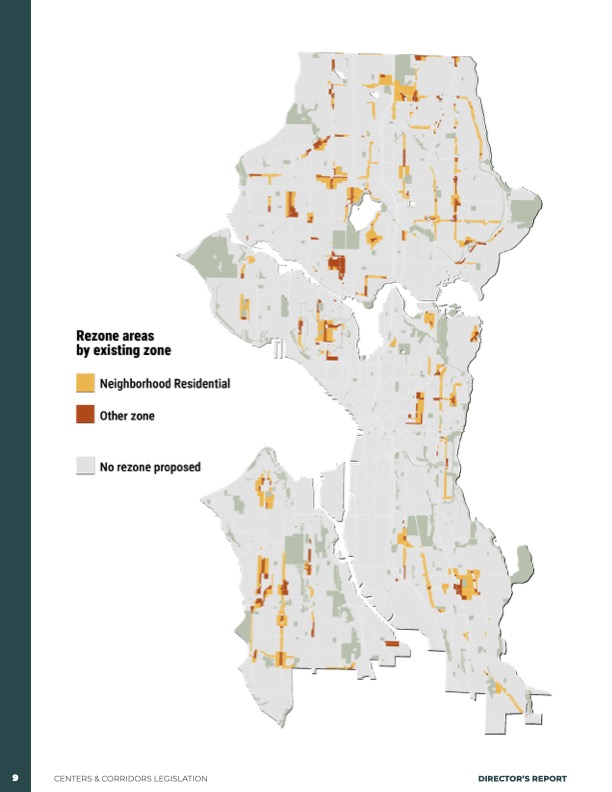
That’s the map included in a city report on the proposals, which we wrote about after the city released them in January. That story led residents of 39th SW north of Morgan in upper Morgan Junction [map] to look into what was planned for their street – using the city’s interactive map.
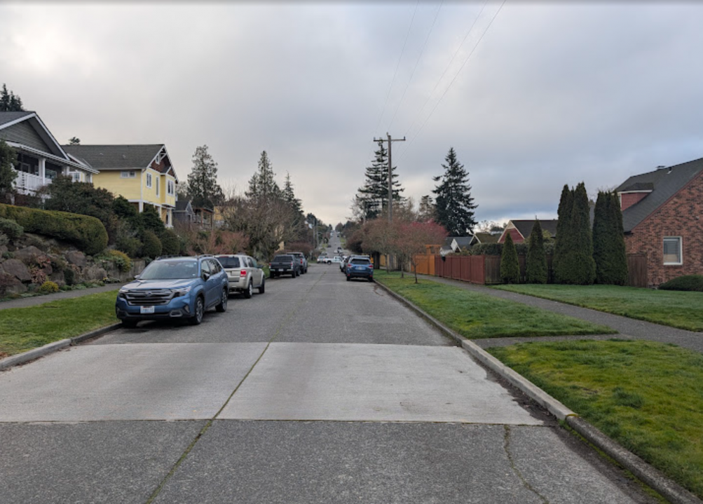
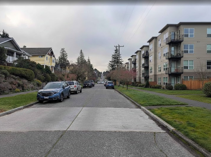
They discovered, Scott Roberts told us, a dramatic contrast between their side of 39th remaining Neighborhood Residential, and what the other side of their street would be zoned for, Lowrise 2. He provided these before and (potentially) after views to demonstrate what he called an “abrupt zoning edge”:
We talked with him and neighbors along their street recently, after one of those neighbors contacted WSB. Their blocks of 39th have many long-time residents; Roberts and his wife have been there 26 years; another neighbor who joined the conversation has been there 29 years; yet another has lived there more than 80 years. (Some newcomers too; yet another told us they’ve lived there three years.) The neighbors have dinners and take trips together and consider each other family. “We’ve put our hearts and souls into this neighborhood,” Roberts says, expecting to live in their 1912-built home for the rest of their lives.
They also expected it would remain a quiet, not-so-dense neighborhood. And they think the proposed zoning change on the west side of the street is based on a mistaken view of how the area fits into the future vision.
They say their street, a long stretch of 39th SW between Holly and Juneau, doesn’t qualify as a “corridor”; it’s just east of Fauntleroy, but buses don’t run there. The closest bus route is the 128 on the SW Morgan hill at the south end of their street. Roberts has done copious research; he and neighbors commented when the proposal was reviewed by the city Planning Commission last month. He’s contacted multiple city offices; so far, he’s heard back from Brennon Staley with the Office of Planning and Community Development, plus an offer to chat with District 1 City Councilmember Rob Saka during his in-district “office hours.”
In correspondence with Staley, Roberts noted it’s not just about height but also about other factors including a 50 percent reduction in required setback in Lowrise 2 – five feet, compared to ten feet for NR – compared to Neighborhood Residential, plus what he describes as “predatory developer pressure,” with property owners already being besieged by builders wanting to buy their homes, even before the rezoning is approved.
Staley’s replies included that the zoning difference was “fairly minor,” with four-story “stacked flats” actually allowable in both zones, plus the observation that the street is 60 feet wide, which he suggested provides “significant separation.”
If the zoning difference is “fairly minor,” Roberts countered to Staley via email, then why rezone at all?” What was “single-family” has already been upzoned, on this block and throughout the city, to at least four units on most if not all parcels, and some neighbors already have added “backyard cottages” (detached accessory dwelling units aka DADUs). Jeff, the 29-year resident, says he’s always been “excited about growth” and even recalled voting for the monorail expansion that once was planned to end at a station half a mile away.
Roberts and his neighbors also say they’re aghast that this change was proposed for their neighborhood – and other changes in other neighborhoods – without direct notification. They’ve been making flyers to circulate. And they’re hoping to convince city leaders to change the plan for their block, as they did with boundaries for some Neighborhood Centers, such as Endolyne before the proposed Centers and Corridors legislation came out.
The ultimate decision is up to the City Council, which starts the review next week and is expected to finalize the Centers and Corridors legislation in July. If you have anything to say about the plan, Roberts and his neighbors note, “Time is of the essence.”
HOW TO GET INVOLVED: Basic info on the Select Committee on the Comprehensive Plan, and its baseline meeting schedule, can be found here. When individual meeting agendas are set – usually a few days in advice – you’ll find them here. Don’t know how to contact councilmembers? Go here.